
![]()
We like to keep our customers and FreeFlight users current on the latest news, by publishing an email newsletter every couple of months. If you are not on our email list, and would like to be, please send an email to StevePo@SeattleAvionics.com. If you think you should be on the list, but are not receiving them, please make sure that emails from StevePo@SeattleAvionics.com are allowed by your spam filter.
| Voyager | SkyPad |
|
November 2013 (Webinar Boot Camp Week, Black Friday, New versions of FlyQ EFB and Voyager) January 2012 (FreeFlight for the iPhone, Voyager 4.5, FAA Price Increase) November 2011 (FAA Price Increase, Black Friday, FreeFlight for the iPhone) November 2010 (iPad apps, Black Friday, SkyPad2 Slate, WebPlan June 2010 (SkyPad2, FAA-certified charts for Aspen) January 2010 (#1 Aviation Consumer / Moved Offices) December 2009 (Special Critical Update Alert) November 2009 (Voyager 4.32 with Data Manager, SkyPad, Black Friday, Windows 7) May 2009 (Voyager 4.2 with Flight Guide and Garmin 430W/530W/G1000 Export) October 2008 (Voyager 4.1 with 3D Airspace, FreeFlight 4.1) July 2008 (Got Glass? All Planes Fly to OSH [Part 1]) May 2008 (Voyager 4.0 Now Shipping) March 2008 (Voyager 4.0 in Beta, New Web Site) October 2007 (Voyager 4.0 almost ready, Web site changes, ChartData specials) August 2007 (Voyager 3.67, Trial Versions, Flying to OSH [Part II: The Flights]) July 2007 (Flying to OSH [Part 1: Planning], Using Google Earth) June 2007 (Voyager 3.6, Fuel Prices, Google Earth) February 2007 (Vista, Personal Air Vehicles) January 2007 (Voyager 3.5, Voyager + iPod offer) June 2006 (Mac Voyager, Data Update, Beta Testers, Not NavData winner) May 2006 (FreeFlight, NavData Contest) April 2006 (Premier Issue) |
December 2010 (New Owners Special
Issue) June 2010 (New SkyPad2) December 2009 (Premier Issue, New SkyPad Controller) |
DUAT Voyager and Voyager 4.4
DTC DUAT and Seattle Avionics introduce new DUAT Voyager, the 100% free, 100% patent-free way to plan flights. Read more...
Voyager 4.36
Added new NOAA magnetic variation tables for accurate magvar calculations from 2010 to 2015. Also added neew IFR charts for the Caribbean, Alaska and the Pacific (incl. Hawaii).
Voyager 4.33
New Data Manager downloads daily and monthly data in the background so Voyager starts much faster. Voyager 4.32 also uses considerably less memory so it runs faster and more reliably. Also adapted to a change in the AOPA Web site that temporarily disabled our FBO data download. Read more...
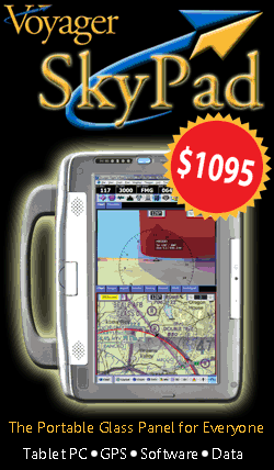
Introducing the New Voyager SkyPad, $1095
Finally, a full-blown Tablet PC, optimized for in-flight use and pre-loaded with Voyager and a full set of charts and plates -- for just $1049!
Introduced to wide acclaim and spectacular sales at AirVenture 2009 (Oshkosh), the new Voyager SkyPad is the portable glass panel for everyone. Read more...
Seattle Avionics Supplies Plates and Charts to Bendix/King for the new AV8OR ACE
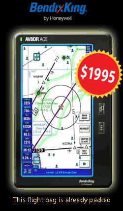
The new Bendix/King (Honeywell) AV8OR ACE is the flight bag that comes fully loaded -- complete with scanned IFR Low Altitude, High Altitude and geo-referenced approach plates from Seattle Avionics. Read more...
New Voyager 4.2
Export to the Garmin 430W/530W/G1000 and AV8OR
Integrated Flight Guide airport diagrams
Various bug fixes
New Voyager 4.1
Airspace in 3D view
Lots of minor fixes
New Voyager 4.0 is now available
Voyager 4 is a huge step forward in the development of Voyager. It is faster (much faster!), which results in better performance and also the ability to quickly "play" with different features, accelerating the learning process. Because 4.0 utilizes a totally different charting engine from 3.6, you must download a new copy of Voyager (that is, Voyager will not automatically update as is usual.) The email you will receive will contain the download links plus a description of the changes. Please read it carefully, perhaps while downloading the new software. It will save you some time and confusion while using 4.0. /p>
Voyager 4.0 Summary:
SPEED So what's the big deal? Well, it can be summed up in one word: SPEED. As you may have noticed, Voyager's strongest suit wasn't its chart drawing speed, so we rewrote the charting engine from the ground up. This time we could take advantage of the same technology that powers Google Earth and Microsoft Flight Simulator, something called Microsoft DirectX. In essence, it means we take all the aviation data, terrain data and the like and put it into a virtual 3D model that mirrors the Earth. Thanks to DirectX, all the heavy lifting of actually drawing the Chart is then handled by your machine's video card at blinding speed.
The result is spectacular and essentially means real-time drawing. For example, in places that the old charting engine might take five seconds to draw a chart, the new drawing engine draws in about 1/5 of a second or less. That is, very conservatively, the new engine is about 100 times faster, better if you have a good video card. This speed makes a night and day difference in using Voyager. Zooms and pans are now silky smooth and GlassView GPS position updates are now every second rather than every five seconds (in fact, the charting engine can do much better than once per second, but most GPS units only update that fast).
SCANNED CHARTS You asked for it; now you have it. Scanned, original, current Sectional, High and Low Enroute, TAC, and WACs can now be used as layers on any Voyager chart screen. And just like our "vector charts", this means you can create your flight plan over any scanned chart, click on an airport (for example) and get airport data, and overlay weather; clouds, radar, Metars and TAFs. Switch to GlassView moving map, and now you have your current position shown on top of a scanned chart. Everything you could do before, you can now do on the new scanned charts!
3-D Not just for Disney movies anymore! You can now turn, tilt, zoom, and rotate charts in all three dimensions! "Pre-flight" your route to visualize your actual flight path. View terrain around an airport to better understand your actual approach. And all incredibly fast!
Please note that current customers who own verison 3.6 must have a current ChartData subscription to upgrade to version 4. Not yet a customer, or not current? You may purchase Voyager and ChartData Subscriptions here.
 |
New Voyager SkyPad
The Glass Panel for Everyone Our new Voyager SkyPad is the hottest thing in aviation GPS devices. For just $1095, you get a full-blown Tablet PC (running an aviation-optimized version of Microsoft Windows XP), all the Voyager software you need for in-flight and pre-flight planning, a WAAS-enabled GPS and a full set of data covering all 50 states. Read more... |
|
New AV8OR ACE
This Flight Bag is Already Loaded Another great way to get Voyager into your cockpit is by using the new Bendix/King AV8OR ACE device. This standalone device includes a built-in GPS, a large and super-bright touchscreen and, best of all, comes pre-loaded with IFR Low Altitude, High Altitude and geo-references approach plates that Seattle Avionics supplies. Read more... |
Trade Show Schedule
 |
Come to the first ever AOPA Aviation Summit! Booth #601 Don’t miss the AOPA Aviation Summit, the premier annual aviation exposition. It’s everything you’ve come to expect from AOPA and more. Tampa, November 5-7. You can find more information at the AOPA Aviation Summit Web site. |
What some of our customers have to say about...

|
|
I have the SkyPad and
LOVE IT! I have been on the sidelines regarding EFBs....always waiting for the perfect unit. While at Oshkosh this year, I had the opportunity to try FlightPrep's ChartCase and Seattle Avionics SkyPad. Both units are well thought out and will likely serve you well. I thought the SkyPad had the upper hand...here is why. -- Doug W Read the whole post... |

|
| "Thanks for the quick response! I love Voyager! I think I've owned every piece of flight planning software that ever came out, but have never been fully satisfied until I installed Voyager last week. And apparently tech support is as good as the software. I will recommend Voyager to my flight studunts." H.W. - CFII |
| "The software is awesome. I have used Aeroplanner, FlightPrep, and Flightsoft in the past. Voyager is by far the best. Keep up the good work!" Mike |
| "Just wanted to let you folks know I am really enjoying your software. I think it is great and very simple to use." Richard |
| "Thank you. I am sending a message of great praise about you and your company to all of my aviating friends. I am very pleased to see that you do in fact listen and respond to what your customers need or want." Matt |
Seattle Avionics Software is proud to be associated with these aviation partners, who share the common goal of providing superior products for the aviation community. |
|
 |
Bendix/King (Honeywel) www.BendixKing.com 1.877.712.2386 |
 |
Airguide Publications |
 |
Advanced Flight Systems |
 |
Aircraft Spruce |
 |
WxWorx |
 |
AvShop, Inc. www.avshop.com 1.866.9.avshop |
 |
Hilton Software, Inc. www.hiltonsoftware.com 1.866.42.WingX |