|
Dear Voyager User, I was painfully reminded that fall is upon us as I recently spent several hours on my roof cleaning the leaves out of the gutters. Hopefully, some of you were out flying, but for many pilots, the departure of the summer sun and arrival of the fall rains signals a winding down of the flying season. Thankfully, the great folks at AOPA have a terrific annual sendoff to summer that they call AOPA Expo which was held this year in Hartford, CT. That's where we were two weeks ago and we had a great time there. Not only did we have fun seeing many existing customers and making lots of new ones, it was the first time we demonstrated the long-awaited Voyager 4.0 that is almost ready to go. More on this below. Flight Log is a recurring newsletter for all Voyager users, with the latest Voyager news, tips and tricks. I'm very interested in your feedback, either to the newsletter or to Voyager itself. Please send any comments or suggestions to me directly at SteveP@SeattleAvionics.com. Back issues of Flight Log are available from our Web site at http://www.seattleavionics.com/Newsletters
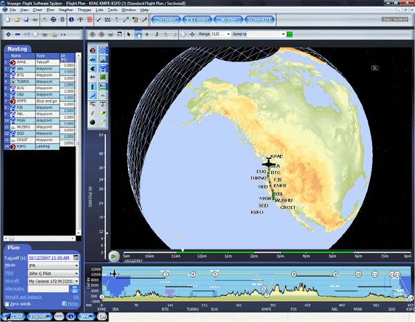
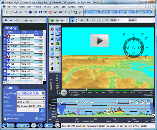
Is this Google Earth or Voyager? Hmmm... Maybe Voyager 4.0? Click for a larger image.
As you may have noticed, AOPA just finished an extensive rework of their Web site. We think the result is tremendous. Unfortunately, it did break the way we download FBO information from the site. A few days after it was up, we had a new version of Voyager (3.68) ready to download. We also corrected a few other minor issues. If Voyager didn't already mention that an update was available, select Update Application from the Tools menu to download it (if you have a current ChartData subscription). You can see all the changes at http://www.seattleavionics.com/v_revis_hist.shtml. Also, the FAA is changing the configuration of Low Altitude IFR charts as of October 25. Instead of 28 charts, the US is being reconfigured into 36 charts to give more space for RNAV routes. We expect a maintenance release (3.69) to be available on that day with the new chart configuration. Click the link below for more information. http://avn.faa.gov/content/naco/SpecialNotices/Reconfig_of_Enroute_Low_Charts.pdf The revised configuration is described visually at http://avn.faa.gov/content/naco/images/ELUS_new.jpg
At least to me, Voyager 4.0 is the most eagerly awaited release we've ever made. It's been in the works for nearly two years and it's almost ready for beta testing (geek-speak for almost ready to release to volunteers who use the software and find problems before we release it to the general public). If you'd like to be on the beta list, please send email to beta@seattleavionics.com. So what's the big deal? Well, it can be summed up in one word: SPEED. As you may have noticed, Voyager's strongest suit wasn't its chart drawing speed, so we rewrote the charting engine from the ground up. This time we could take advantage of the same technology that powers Google Earth and Microsoft Flight Simulator, something called Microsoft DirectX. In essence, it means we take all the aviation data, terrain data and the like and put it into a virtual 3D model that mirrors the Earth. Thanks to DirectX, all the heavy lifting of actually drawing the Chart is then handled by your machine's video card at blinding speed. The result is spectacular and essentially means real-time drawing. For example, in places that the old charting engine might take five seconds to draw a chart, the new drawing engine draws in about 1/5 of a second or less. That is, very conservatively, the new engine is about 100 times faster, better if you have a good video card. This speed makes a night and day difference in using Voyager. Zooms and pans are now silky smooth and GlassView GPS position updates are now every second rather than every five seconds (in fact, the charting engine can do much better than once per second, but most GPS units only update that fast). Click the links below to play example video clips of Voyager 4.0 in action. Note: In order to make the videos playable over the Internet, we had to skimp on the image quality a bit. Apologies for the "bad VHS" look in a few places — the real images are crystal clear.
This speed also let us add one of the most-requested features ever — scanned charts that show the flight plan line and aircraft position. In fact, we went well beyond that. In essence, we borrowed from Google's playbook once more and Voyager can now use Sectionals, IFR Low Altitude and IFR High Altitude charts as just one of the many chart layers. Thus, you can display radar and satellite, not to mention current fuel prices and TFRs, over your favorite scanned chart. Better still, rather than having to select which specific chart to overlay (like the Seattle North Sectional), we seamlessly merge all the scanned charts so when you turn on the Sectionals layers, Voyager automatically pulls the pieces it needs from all the relevant Sectionals, resulting in much less pilot workload. There are lots of other changes in Voyager 4.0, mainly subtle but useful changes in GlassView, but I'll wait to go into more detail when it ships. In the meantime, my main message is simple: Don't let your ChartData subscription lapse or you'll miss the free upgrade to Voyager 4.0. Which brings us nicely to our next topic.
Over the years, we've heard many times that's it's hard to figure out which products to buy from our Web site. All the different modules and ChartData subscriptions could give anyone a headache. Even Aviation Consumer, which truly gushed about Voyager when it crowned the best flight planner, went out of its way to mention how confusing purchasing was. Well, we've fixed that. Not only have we changed the way we present our offerings, we've lowered our initial purchase prices to make it easier to get into the Voyager family. For example: While you can still buy Voyager a module at a time, we put a lot of emphasis on common bundles of modules and ChartData, with a nice discount, of course. For example:
Additional offers are on the Web site. These are just some examples. Click the links to buy any of these bundles. We also changed our ChartData subscriptions a little, both in terms of what each level includes and the price. Our VFR ChartData subscription is unchanged, remaining at $99. It's probably the best bargain in all of aviation as it includes all application updates, digital navigational data downloaded every 56 days, scanned Sectionals and TACs, and the recently added daily fuel price downloads — in essence, everything you need for VFR pre-flight planning. And, when used with Voyager 4.0, the Sectionals become geo-referenced so you can view them just like any other Chart layer. The IFR ChartData level is now $199 (up from $149) and includes everything in the VFR subscription plus scanned IFR Low, IFR High and WAC Charts. Also, and most significantly, this level also includes the standard non-geo-referenced approach plates. Put differently, buying SmartPlates no longer provided free plates. If you currently own SmartPlates and do not have a ChartData subscription, we will, of course, honor our original promise to provide the plates to you for no additional fee; this new policy only applies to new purchases. The EFB level of ChartData is now $299. It adds geo-referenced approach plates and airport diagrams to the IFR level and is what you want if you fly with Voyager on a tablet PC.
The prices changes are effective immediately. However, if you buy with Coupon Code Renew2007, you can extend your existing ChartData subscription for up to an additional two years at the old prices. In fact, if you extend now for another two years, we'll add an additional six months of ChartData for free. In other words, you can purchase 30 months (two years + six free months) of IFR ChartData for just $298, versus $498 at the new prices. Click below to take advantage of the offer. https://www.seattleavionics.com/eCommerce/buy1.aspx?CouponCode=Renew2007
The US Department of Defense used to provide navigational data for airspace and airports all around the world. About a year ago, they began to limit the data to the US only, which is why our Canadian and Mexican data have not been updated in a year. As of October 1, they no longer produce the data at all. The FAA is in the process of filing the gap with their own digital data, but they're not entirely done yet. In particular, their airspace data doesn't include communication frequencies and is missing Class A definitions. There probably will be other subtle differences as well. We've been working with them for some time on these issues and they promise corrections but they aren't ready yet. On the other hand, their data is better updated and includes some additional airway and preferred route information so, going forward we're excited to get the data closer to the original source. The next ChartData update, due October 25, will use the FAA not DoD data. Finally, the DoD used to update their data every 28 days while the FAA uses a 56-day cycle. Approach plates are still updated on a 28-day cycle. Thus, in the near future, we expect our VFR ChartData to be updated every 56 days while the IFR and EFB ChartData (which now include approach plates) will be updated every 28 days. We're a computer software company not a computer hardware company. That means we lose money every time we sell a tablet PC or other hardware once you take all the overhead into account. Even worse, we haven’t been able offer you the lowest prices. Therefore, we're pleased to announce a partnership with Complete Tablet Solution (CTS), a leader in tablet PCs and an authorized Motion Sales and Service center. The arrangement is simple; you purchase software from us, hardware from CTS, then CTS installs and configures it all so the unit is delivered complete and ready to fly. CTS offers the complete range of Motion Computing tablets and accessories, plus other hardware you need like Lind DC power adapters, GPS receivers, and XM satellite weather receivers.
Special for LS800 owners: We sold 32GB solid state drive upgrades for $949. The new price from CTS is only $799 plus freight. You can contact CTS at 1-866-780-7480 x105, or on their Website at www.CompleteTablet.com/SA As always, please send your questions and favorite tips to SteveP@SeattleAvionics.com. A reminder that past Tips and Tricks are
available from our Web site at
Seattle Avionics Software will be showing Voyager at the following upcoming events. Stop by to say hello, see the latest Voyager features, and ask the experts any questions you have about Voyager. February 23 - 24, 2008: Northwest Aviation Conference and Trade Show. Puyallup, Washington. April 8 - 13, 2008: Sun 'n Fun Fly-In. Lakeland, Florida. Until next time, happy flying.
- Steve Podradchik, CEO (and Editor)
|
|||||||||||||||||||||||||||||||||||||||


