Spacer Spacer Spacer Spacer Spacer Spacer Spacer Spacer
Top Spacer
Product Info and Prices Buy Now Support Information Community Page Company Information
Blank Spacer
Individual Module Details
 

Voyager FSS            Voyager Flight Software SystemSmartPlanSmartPlatesGlassViewWXChartData
The Voyager Flight Software System is a complete software system that makes flying safer and more enjoyable.  Preflight, it can check the weather and plan a wind-optimized, fuel-price optimized flight.  In flight, it puts a tremendous amount of information at your fingertips in a way that's quick and easy to understand.

Voyager is modular so you can buy as many or as few features as you need and upgrade easily if your needs change.  For example, we sell packages packages tailored for VFR pilots, IFR pilots and for those who carry a tablet PC into the cockpit for in-flight use.  You can also purchase each module separately but most pilots begin with a complete package.

You can view each of the individual Modules by choosing one of the options on the left.

You may also use one of the follwoing shortcut links if you are looking for something specific:
Buy NowGo To Webinar PageWhats NewProduct Demo VideosProduct Downloads


SmartPlan Module

Saves You Money Every Time You Fly!

Fact is, there are many flight planners out there, many are free.  Any of these can give you the heading from A to B.

But if you want to spend more time — and less money — flying, Voyager's SmartPlan module is the clear winner.

From your first moments with it, you'll see that the whole planning experience is different and why Aviation Consumer raved, saying it "leaves competitors in the dust."  Much more intuitive user interface, much clearer information, more 'under the covers' automation, and, frankly, much more fun.

SmartPlan


New Features
Fuel Exclusive new SmartFuel™ uses current fuel prices to find the cheapest fuel along your route.  Voyager Charts now show fuel prices right on the screen for every airport.
SmartPlan True 3D wind optimized autorouter gets you there faster and using less fuel.
Map New Google Maps integration shows you a satellite image of airports so you know what it looks like before you call the tower.
Map New Google Earth integration means you can pre-fly your flight in photo-realistic 3D, with real satellite images.
Web Synch Exclusive Web Synch makes it a snap to share flight plans and plane/pilot profiles between multiple computers.
Card Synch New Memory Card Synch lets you use a memory card or USB memory stick to bring all your data with you and run Voyager on any PC.
WX Integrated satellite and radar overlays and seamless Internet connectivity means everything you need is in one place; no browsing a dozen or more Web sites for weather, fuel prices, FBO info, etc.

Other Major Features
Integrated Weather Integrated weather automatically downloaded and shown on all Charts.  Exclusive timeline lets you see how weather changes during your flight.  NexRad, satellite, winds, etc.
Autorouting Autoroute by GPS Direct (avoiding terrain), Victors or Jet airways, automatically avoiding TFRs and other restricted airspace.
SmartFuel Prices SmartFuel automatically finds cheap fuel.  Fuel prices at every airport shown on the Chart. ChartData subscription also required.
Airport Satellite Images Detailed airport info including Google Maps satellite images and AOPA FBO info.
3D Previews Preview flights in stunning 3D using new Google Earth export.
True Scanned Charts True FAA scanned Sectionals, IFR Low and High Altitude, and TACs ChartData subscription also required.
Automatic Data Update Data kept current automatically in the background through your Internet connection.
Detail Profile View

Profile view shows flight over terrain, airspace, airway MEAs and cloud layers.

Comprehensive Printing Prints extensive printed trip kits, kneeboard or full page.  Extremely easy to customize.
Electronic Filing File and print FAA and ICAO flight plans.
Licensed for 3 Computers Licensed for installation on three PCs (e.g. home computer, work computer, laptop or Tablet PC).
Web Synch Easily keep multiple computers in-synch with the same flight plans, pilot and aircraft profiles, etc.
Create Plans with a Wizard or Quick Mode Bypass the New Flight Plan wizard and create a wind-optimized flight plan just by entering idents.
Alternate Airport Selection Select alternates using the best choices of expected weather, distance, time, and fuel.
FAA Preferred Routes Automatically finds FAA Preferred Routes.
High-Performance Aircraft Profiles Sophisticated profiling for high-performance piston, turbo, turbine and jet aircraft, for all weights and temperatures.
Selective Airspace Avoidance Select any class or classes of airspace to avoid.  Even avoid flying over water for an extended period of time.
SIDs/STARs SIDs and STARs integrated into autorouting and can be added to the flight plan later.
Export to Garmin and Other Handheld GPS Export to the Garmin handhelds 296, 396, 496, etc. as well as the Lowrance AirMap 500/1000/2000c, Control Vision Anywhere Map and Hilton Software WingX.

SmartPlates Module

The Smart Approach to Approaches

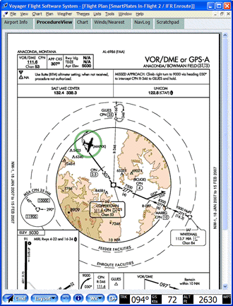
There are few things in life more fun than getting a new stack of approaches in the mail and spending a beautiful Saturday afternoon organizing them.

Of course, if you've gone paperless, you can download individual plates from the FAA but then you have the joy of figuring out which have changed recently and which you have time to download one by one.  And, lets not even talk about what happens when you have to divert to an unplanned airport and you, uh, misplaced the current approaches for it.

That's what SmartPlates is all about.  It manages your plates so you can go out and fly.  It knows which change every month and automatically downloads the ones you need.  Or all 13,500+ if you prefer.  Either way, your plates are there on your PC or Tablet PC, ready and waiting.  Even print them two-per page or full page.  Or put them on a memory card and take into the plane.

Best of all, combine SmartPlates with GlassView and watch your plane move along the plate as you fly.  Computer guys call it "geo-referencing" but you'll call it magic.

Note:  An IFR or EFB level ChartData subscription is required to keep your plates current.

SmartPlates

SmartPlates All 13,500+ US Plates:  ILS, LOC, GPS, RNAV, VOR, DME, NDB, LDA, SDF, MLS, HI.  Arrivals, departures, airport diagrams, etc.
SmartPlates All 50 states.
SmartPlates Install and run on up to 3 PCs — desktops, laptop, tablets — for the same price.
Fuel Integrated, on-screen fuel prices help you decide where to land.
GlassView Geo-referenced plates show your plane's position on the plate as you fly it.
GlassView Specific layouts for pre-flight and in-flight provides optimal experience in any environment.
SmartPlates Download plates from either the FAA's NACO site or select Seattle Avionics smaller, pre-processed plates for 5x faster downloads.
Sectionals Combine with a ChartData subscription for true IFR scanned Low and Hi Enroute Charts (and Sectionals and TACs and WACs).  An IFR or EFB ChartData subscription is also required to keep the plates current.


GlassView Module
Safe Flying - 21st Century Style

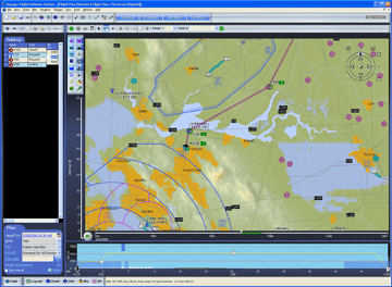
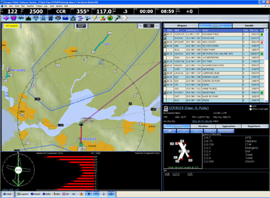
Back in the day, you flew with steam gauges and a radio and it was good.  Then came the GPS and you couldn't believe you ever flew without a moving map.

Get the same feeling all over again with GlassView.

Far beyond a simple moving map, GlassView and a Tablet PC gives you the full glass cockpit you've always dreamed of.  And one that will get jealous stares from everyone at the FBO.

Everything you need on the screen, clearly organized and easy to read.  Charts, weather, approach plates, airport info, fuel prices and our unique Wind Optimizer that constantly updates with the best altitudes.  Even jot down ATC clearances and notes on the new Scratchpad.

GlassView

   
GlassView Multiple screen configurations (layouts) automatically adapt to different screen sizes and orientations.  Version 3.6 adds several new layouts.
GlassView Split-screen shows two Charts or one Chart and an approach procedure
SmartPlates Aircraft moves over approach procedures and airport diagrams as you fly.
GlassView Unique Wind Optimizer constantly provides feedback for the right altitude, given the winds.
SmartPlan Integrated NavLog designed specifically for easy in-flight use.
GlassView Smart Direct To knows where you are and provides lists of nearby airports and navaids so you can click rather than type.
Fuel Fuel prices integrated throughout shows fuel prices on the Charts, in the list of nearby airports, etc.
GlassView New GPS simulator makes it easy to fly a virtual flight.
GlassView "Single-Click Everywhere" design philosophy means most things are just a click away and you never have to use a right-mouse click or type while flying.

See everything that's new in version 4.x.

GPS hardware is required for GlassView; please see our hardware page for options.  Some features require a ChartData subscription.


Weather

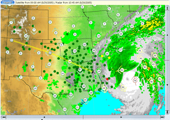
Stay Out of the soup with Real-Time In-Cockpit Weather

Fly with the safety and confidence that only in-cockpit weather can provide.

Weather information has always been outdated as soon as the weather briefing ended.  No longer. Now you can receive real-time weather updates from an XM satellite while en-route.  New weather is automatically incorporated into GlassView, making your weather Charts more lively than most TV shows.

Weather information is constantly updated and delivered in high resolution.  XM satellite weather assures you of current weather information anywhere you fly in the contiguous 48 states.

Weather

Weather TFRs
Weather METARs
Weather NexRad Radar
Weather TAFs
Weather Cloud Tops (Satellite) *
Weather Echo Tops *
Weather Lightning Strikes *
Weather Winds Aloft *

Hardware and an XM WX subscription are required. please see our hardware page for hardware options.   XW WX subscriptions are available from WxWorx.  All XM products require at least the Aviator Lite Package and those marked with * require the higher Aviator Package.


ChartData

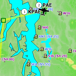
Finally!  An Aviation Subscription That Actually Saves You Money

If you fly, you pay.  It's a fact of life that flying isn't cheap.  And getting more expensive all the time.

Or is it?  Through a partnership with AirNav.com, our ChartData subscriptions now include constantly updated fuel prices from more than 2,300 US airports.  Every time you fly, Voyager's autorouter automatically finds cheap fuel, saving you real money.  And you can look at any Voyager Chart to see fuel prices along your route. During an introductory period, SmartFuel™ is included in your ChartData Subscription for no additional charge!

Not only that, our ChartData subscriptions replace many of the old-fashioned paper charts that live in your plane's back seat with clear, crumple-proof digital charts.  You get the true FAA scanned Sectionals, TACs, Low and High Altitude Enroute Charts.   100% legal.

Finally, the name ChartData is a little misleading as each subscription also keeps you current with all the new versions of each Voyager module we make during the subscription.  We would tell you what to expect but then we'd have to ... well, you get the idea.

What's Included?
We strongly recommend the subscription service for safe flying. 12 Month ChartData Subscriptions are available at three different levels.

Voyager VFR:  Ideal for VFR pilots.
  • US (incl. AK, HI, PR and USVI) navigational databases revised by the FAA and DoD (DAFIF) every 28 days and downloaded automatically.  This includes airspace, airport information, airways, navaids, etc.  Canadian and Mexican data is included, but is not updated at present (read more).
  • Updates, including all fixes and new features, to all Voyager modules, downloaded automatically from the Internet.
  • Scanned geo-referenced Sectional Charts
  • Scanned Terminal Area Charts (TAC).
  • Technical support via phone and email.
  • SmartFuel fuel prices
SmartPlates IFR:  Ideal for IFR pilots without an EFB.

Includes everything at the VFR level plus:

  • Scanned geo-referenced IFR Low Altitude Charts
  • Scanned geo-referenced IFR High Altitude Charts
  • Scanned approach plates (not geo-referenced)
GlassView EFB:  Ideal for any pilot flying with an EFB.

Includes everything at the IFR level plus:

  • Geo-referenced approach plates and airport diagrams.


Fuel Prices

Sectional

Enroute Chart