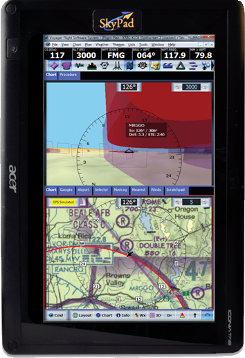
>> Learn more about Voyager
Microsoft Windows 8, 7, Vista, or XP. Requires
2 GB of RAM.
- Seamless, geo-referenced U.S Sectional Charts with embedded Terminal Area Charts (TAC)
for all 50 US States
- Seattle Avionics ChartData™ US navigational database (incl. AK, HI, PR and
USVI) revised every 28 days. This includes airspace, airport information, airways, navaids, etc.
- More than 700 Seattle Avionics geo-referenced FAA Airport Diagrams for all 50 US States
- Fuel prices for more than 2,000 airports
- Terrain and obstacle warnings
- 3D Synthetic Vision, 3D Terrain, HITS (Highway-In-The-Sky)
- Seattle Avionics geo-referenced Approach Plates for all 50 States.
- Seamless, geo-referenced IFR Low Altitude Charts for the continental US (including Alaska) plus the Caribbean
- Seamless, geo-referenced IFR High Altitude Charts for the entire US (including Alaska and Hawaii) plus the Caribbean and the Pacific
- Supports XM for inflight weather
- Terrain profile view
- SIDs/STARs
- More info...
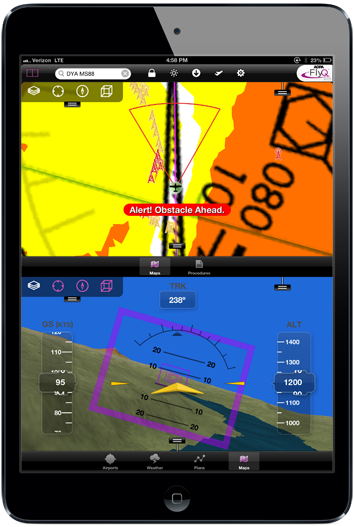
>> Learn more about AOPA FlyQ EFB
Designed for the iPad 2 (or newer) and the iPad mini.
Does not work with the iPad 1.
- Seamless, geo-referenced U.S Sectional Charts with embedded Terminal Area Charts (TAC)
for all 50 US States
- Seattle Avionics ChartData™ US navigational database (incl. AK, HI, PR and
USVI) revised every 28 days. This includes airspace, airport information, airways, navaids, etc.
- More than 700 Seattle Avionics geo-referenced FAA Airport Diagrams for all 50 US States
- Fuel prices for more than 2,000 airports
- Terrain and obstacle warnings
- 3D Synthetic Vision, 3D Terrain, HITS (Highway-In-The-Sky)
- Seattle Avionics geo-referenced Approach Plates for all 50 States.
- Seamless, geo-referenced IFR Low Altitude Charts for the continental US (including Alaska) plus the Caribbean
- Seamless, geo-referenced IFR High Altitude Charts for the entire US (including Alaska and Hawaii) plus the Caribbean and the Pacific
- AOPA Airports Directory information, including over 3,100 airport diagrams and AOPA member comments
- Supports multiple ADS-B receivers for inflight weather
- More Info...
© Seattle Avionics | 19825 141st Place NE | Woodinville, WA 98072 | Phone 425-806-0249 | Email sales@seattleavionics.com